Land surveying: The foundation of construction
Subheading: Traditional land surveying methods
Land surveying is the process of measuring and mapping the Earth’s surface. It is an essential part of any construction project, as it helps to ensure that the project is completed accurately and on time.
Traditional land surveying methods involved using a variety of tools and instruments to measure distances, angles, and elevations. These methods were often time-consuming and labor-intensive, and they could be prone to errors.
Subheading: Modern land surveying technologies
Modern land surveying technologies have revolutionized the industry, making it more efficient and accurate than ever before. Some of the most commonly used modern land surveying technologies include:
- GPS (Global Positioning System): GPS uses satellites to determine the precise location of a point on the Earth’s surface. GPS is one of the most accurate land surveying technologies available, and it is widely used for a variety of applications, including boundary surveys, topographic surveys, and construction surveys.
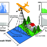
- LiDAR (Light Detection and Ranging): LiDAR uses laser light to measure distances and create 3D models of the Earth’s surface. LiDAR is particularly useful for surveying large areas of land, and it is often used for topographic surveys and construction surveys.
- UAVs (Unmanned Aerial Vehicles): UAVs, also known as drones, are increasingly being used for land surveying. UAVs can be equipped with high-resolution cameras and GPS receivers to collect data from areas that are difficult or dangerous to access on foot. UAVs are often used for topographic surveys, boundary surveys, and construction surveys.

Subheading: Benefits of modern land surveying technologies
Modern land surveying technologies offer a number of benefits over traditional methods, including:
- Increased accuracy: Modern land surveying technologies are more accurate than traditional methods, which can help to reduce errors and ensure that projects are completed on time and within budget.
- Increased efficiency: Modern land surveying technologies can help to reduce the time it takes to complete a survey. This is especially beneficial for large projects or projects with tight deadlines.
- Reduced costs: Modern land surveying technologies can help to reduce the cost of surveying. This is because modern technologies are more efficient and less labor-intensive than traditional methods.
- Improved safety: Modern land surveying technologies can help to improve the safety of surveyors. For example, UAVs can be used to survey dangerous areas that would be difficult or dangerous for a surveyor to access on foot.
Conclusion
Modern land surveying technologies are revolutionizing the industry. These technologies offer a number of benefits over traditional methods, including increased accuracy, efficiency, cost savings, and improved safety.


